
Case Study: Ningaloo region
Case Study - Ningaloo region
The Ningaloo region is recognised as an area of high ecological importance with unique environmental, social and cultural values. The Ningaloo Reef is Australia’s largest fringing coral reef, extending across 280 kilometres of coastline between Exmouth and Carnarvon, Western Australia. This area is a global biodiversity hotspot and was inscribed on the World Heritage List in 2011. Exmouth Gulf has increasingly been seen as critical habitat for threatened and migratory whales species (southern right whale and humpback whale), dugongs, migratory shorebirds and a variety of other threatened marine species. Woodside has two offshore assets adjacent to the world heritage area being Ngujima-Yin and Pyrenees Floating Production Storage and Offloading (FPSO) facilities.
To better understand and manage the environmental features of the region, Woodside has supported a range of multi-years projects through our environmental partnerships program. These projects have focused on iconic species and habitats across a range of different ecosystems both along the Ningaloo Reef and Exmouth Gulf. These social investment and science funded projects contribute to conservation efforts, biodiversity education, and community engagement and outreach at a local and regional scale.
Understanding Ningaloo Reef - Ningaloo Outlook (CSIRO)
Within the Ningaloo World Heritage Area, in 2024 Woodside continued to support a project called Ningaloo Outlook with the Commonwealth Scientific and Industrial Research Organisation (CSIRO) which continues to improve the understanding of Ningaloo’s reef systems and their iconic inhabitants. Ningaloo Outlook also supports a PhD scholarship program and involves active participation by Woodside staff and the community of Exmouth, including students and teachers from the local school. To date, the research has included 65 expeditions involving dozens of CSIRO researchers, who took a myriad of measurements and deployed a wide range of instruments from autonomous underwater vehicles to satellite tags. Researchers have tagged over 690 individual turtles, whale sharks and coastal sharks using technologies ranging from simple metal tags to more complex acoustic and satellite tags. More than 3,000 members of the public, including school children, participated in the research and education. Many more were engaged through public presentations and online tools. In 2023-24, the Ningaloo Outlook program undertook seven expeditions to Ningaloo Reef and published four research papers in international peer reviewed journals and gave 17 public presentations. In addition, over 500 individuals were actively involved in either the research or education programs. The program continues to support future science capability, funding four PhD students in 2024. This scientific knowledge continues to be shared with government and industry, as well as the broader community.
.tmb-lightbox.jpeg?sfvrsn=63cd1e14_1)
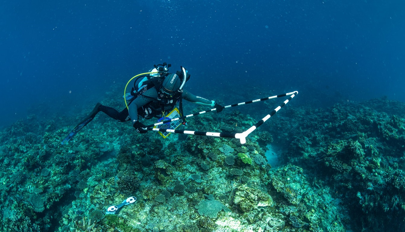
Left photo: Dr Melanie Orr placing a quadrat on the substrate before taking a sequence of photos that will be used to build an orthomosaic, as part of the Shallow Reefs project in the Ningaloo Outlook program. Image credit Nick Thake (NTPV)
Right photo: Dr Mat Vanderklift (Theme Lead of Ningaloo Outlook: Turtles) teaching Exmouth District High School students about the Ningaloo Outlook program, specifically the Turtle Tagging work undertaken by CSIRO over the last 10 years. Image credit Violeta Brosig (Blue Media Exmouth)
Monitoring and Management of Ningaloo Turtles (DBCA)
Ningaloo Marine Park has regionally and globally significant nesting for ‘endangered’ loggerhead and ‘vulnerable’ green and hawksbill turtles, as listed under the Environment Protection and Biodiversity Conservation Act 1999 (Commonwealth) and Biodiversity Conservation Act 2016 (WA) (Commonwealth of Australia 2017). The loggerhead rookery in Cape Range National Park is regarded as the largest mainland rookery for the Western Australian loggerhead genetic stock.
The Ningaloo Turtle Program (NTP) was established by the Department of Biodiversity, Conservation and Attractions (DBCA) and collaborating organisations in 2002 and is a flagship community volunteer turtle-monitoring program. The program tracks marine turtle nesting activity on an annual basis providing long term trends for species such as green, loggerhead and hawksbill turtles which feed, rest and nest within the Ningaloo Marine Park and Ningaloo Coast World Heritage Area.
The 2023-2024 season was the 22nd of the NTP. Forty-eight volunteers (with assistance from eight Woodside personnel accompanying the NTP volunteers) contributed 3892 hours to turtle nesting beach monitoring patrols and since commencement of the program, volunteers have contributed over 87,902 hours. During the season, outreach activities and communications about turtle nesting were conducted, including raising awareness of the DBCA Turtle Watching Code of Conduct.
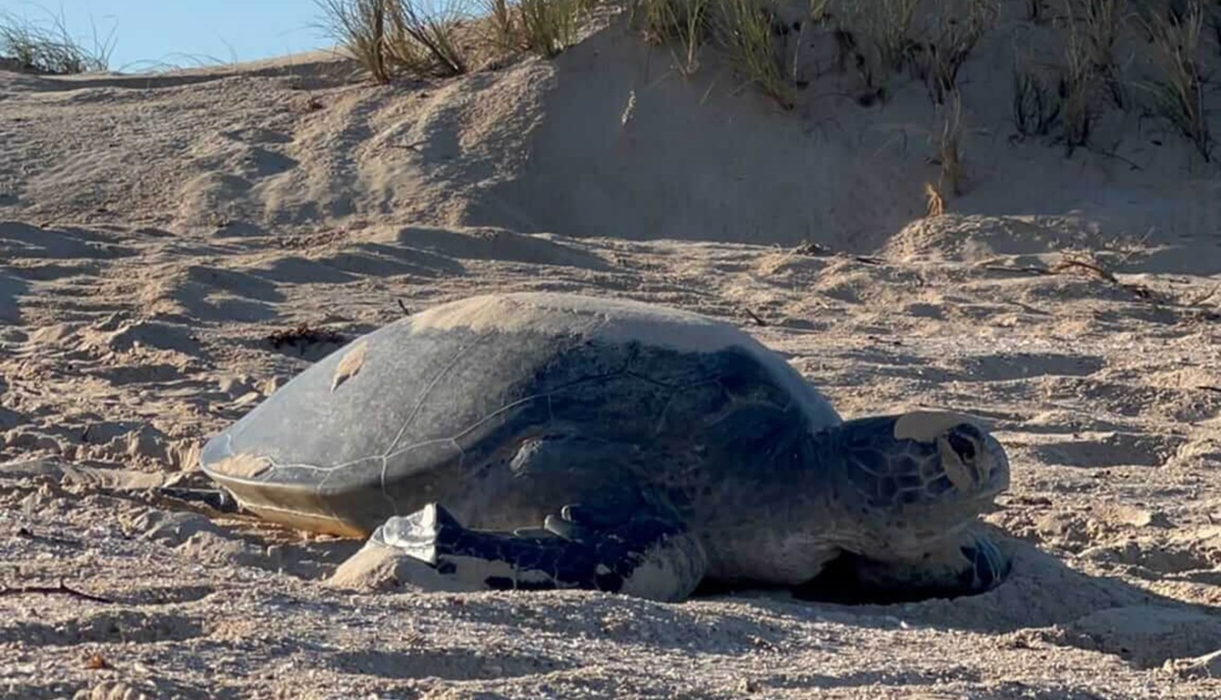
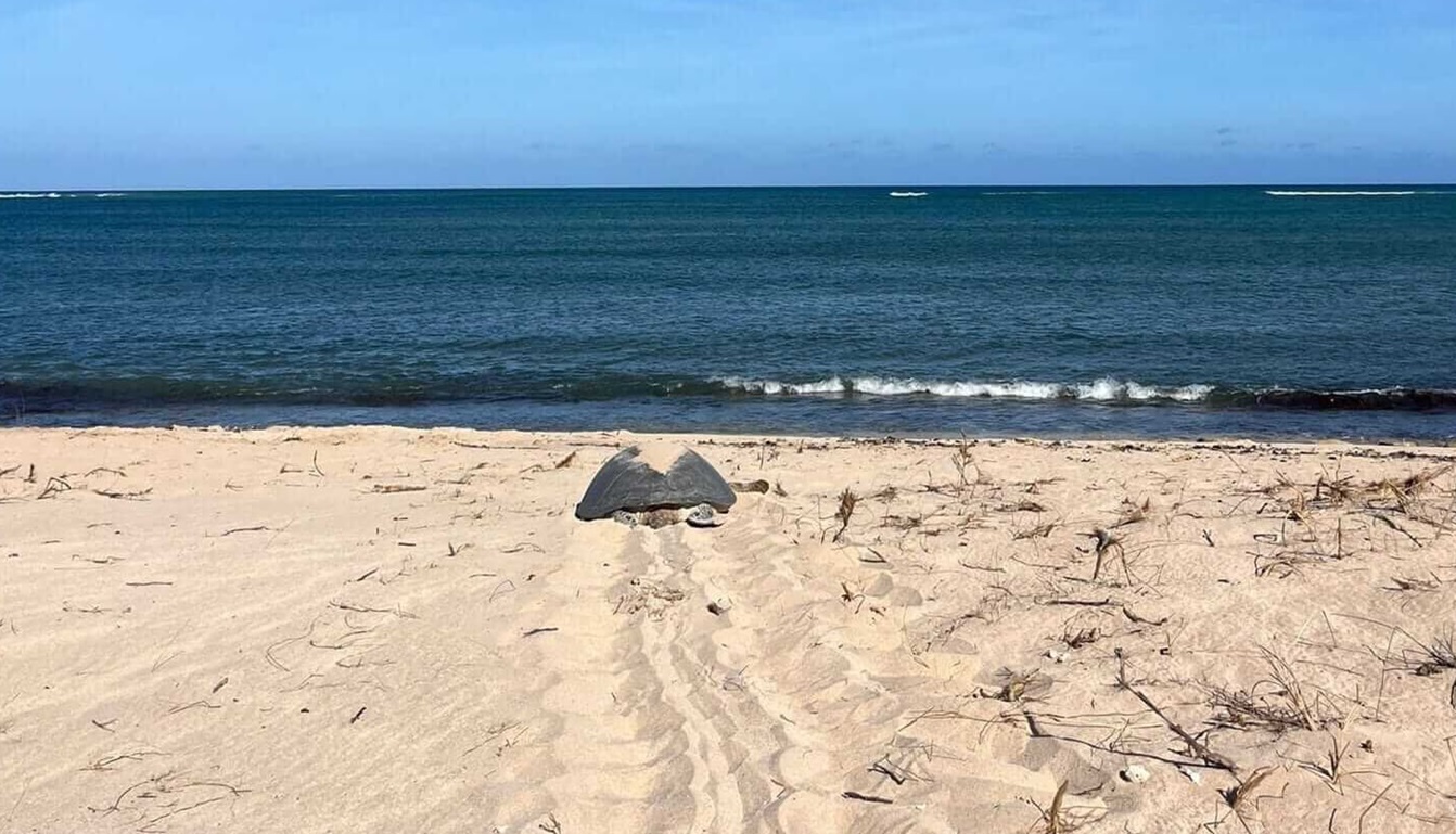
Left to right photos: A female green turtle returning to the water after nesting. Image credit Zara Handscomb / NTP (left photo); Maddie Cayley/NTP (right photo)
In the 2023/2024 season, monitoring was completed along the North West Cape, Cape Range and Coral Bay divisions, which consists of multiple beach subsections. A total of 6049 suspected nests were recorded for three species of marine turtle: green, loggerhead and hawksbill. In both the North West Cape and Cape Range divisions, it was the second highest season (out of 22 seasons) for the number of green turtle nests, while the number of nests for hawksbill were lower than average and for loggerhead were the lowest on record. The nesting success was below average for all three species in the 2023-2024 season. Further, 286 nests were assessed as being disturbed, with 266 of these attributed to ghost crabs. A total of 52 stranded turtles were rescued and returned to the ocean during beach monitoring patrols.
The primary threat to emerging turtle hatchlings, is the golden ghost crab (an endemic crab species to Ningaloo) as crabs prey on turtle hatchlings immediately after emergence from nests as well as burrowing down into the egg chamber while the eggs are incubating. Woodside has provided financial support for studies including a PhD research program with Edith Cowan University and DBCA that confirmed these ghost crabs are a major predator of green and loggerhead turtle hatchlings, at the major rookeries within the Ningaloo Coast UNESCO World Heritage Area. DBCA conducted a further assessment of ghost crab predation on loggerhead hatchlings on Dirk Hartog Island and South Muiron Island in 2023, which complemented the data collected from Gnarraloo Bay and Bungelup Beach (2020-2022), with these four locations together forming the main rookeries comprising the Southeast Indian Ocean loggerhead turtle stock. These studies together formed the basis of investigation strategies to decrease predation on loggerhead turtle eggs and hatchlings along the Ningaloo coast. In 2024-2025 turtle nesting season at Ningaloo, DBCA are trialing elements of the strategies with partial funding support from Woodside.
The NTP and ghost crab research supports the long-term ecological understanding of these threatened and migratory marine turtle species and allows for better environmental management at key nesting locations in Western Australia. Woodside and Joint Venture Participants have committed funds to support the NTP for a further three years (up to and including the 2026-2027 turtle nesting season).
-web.tmb-lightbox.jpeg?sfvrsn=8b520199_1)
-web.tmb-lightbox.jpeg?sfvrsn=96cd8196_1)
Left to right photos: Volunteers learning the art of interpreting turtle tracks left on the beach by nesting turtles overnight. Image credit Maddie Cayley/NTP
Migratory Shorebirds of Exmouth Gulf (Birdlife Australia)
The Exmouth Gulf, adjacent to the Ningaloo Coastal World Heritage Area, is an extensive area comprising a myriad of diverse coastal and marine habitats supporting resident and seasonal threatened species, including internationally significant numbers of migratory shorebirds. Woodside partnered with Birdlife Australia to collect scientific information on the actual species present, their distribution, abundance and behaviours within the Exmouth Gulf.
In 2023, BirdLife Australia and collaborators undertook field work within the Exmouth Gulf to capture migratory shorebirds, with the goal to compare the population connectivity and site fidelity of Exmouth birds with shorebirds captured elsewhere in Western Australia. Fitting shorebirds with bands and leg flags allowed BirdLife to monitor population changes (such as recruitment, adult survival, and population sex and age structure) when birds with leg flags are resighted. Over two field trips, 274 birds were captured and fitted with engraved leg flags, and a further 10 Bar-tailed Godwits—one of the largest shorebird species—were tagged with a small satellite transmitter. These satellite tags are providing insights into this iconic shorebird species’ finer-scale ecological movements, feeding and roosting habitats and their international transboundary biannual migration. Rounds trips of over 25,000 km have been recorded and confirm the incredible distances Bar-tailed Godwits cover on their international migratory journeys.
Preliminary results suggest that Bar-tailed Godwit have a high level of site fidelity within the Exmouth Gulf; they do not appear to be using the Exmouth Gulf as a stop-over site on the way to or from other areas of Western Australia. On their northward migration to their breeding grounds in the Arctic Tundra, Exmouth Bar-tailed Godwits utilise similar migratory routes through the Yellow Sea to those of other godwits tagged in other parts of northwest, Western Australia. For example, many foraged on Anzhu Island (New Siberian Islands) after breeding on the Siberian Tundra.
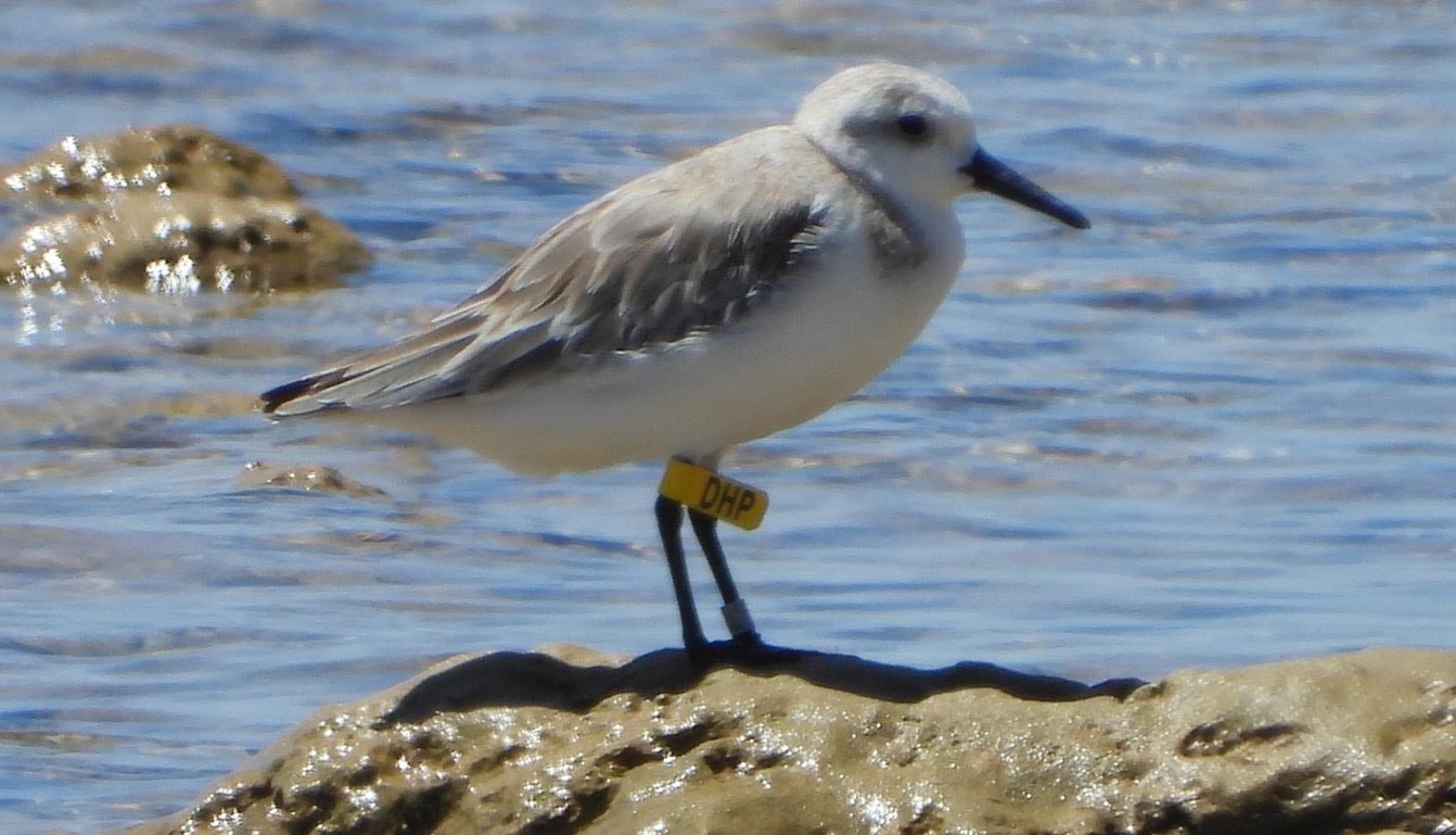
Satellite tags continue to transmit data on the location of tagged Bar-tailed Godwit within the Exmouth Gulf. In addition BirdLife Australia have collected data on re-sightings for 125 leg-flagged shorebirds within the Exmouth Gulf. These include: 58 Bar-tailed Godwits, 33 Great Knots, 27 Greater Sand Plovers, five Sanderlings and two Red-necked Stints. Community members participated in field work to monitor migratory shorebirds and monitoring of migratory shorebirds continues annually in the Exmouth Gulf. Community and Indigenous Ranger outreach and capacity building programs included at least three events with over 90 participants.
All research was carried out in accordance with State and Federal permitting requirements.
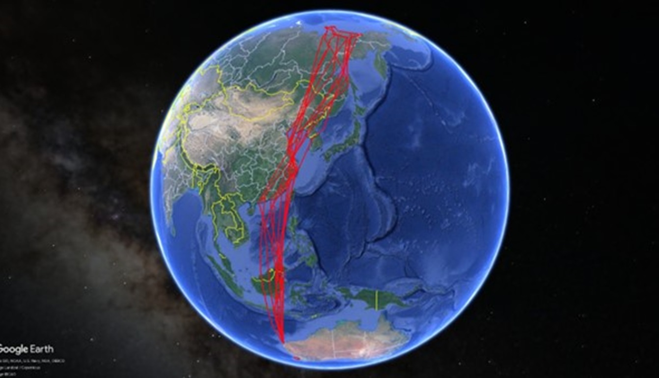
Top left photo: Migration pathways for ten Bar-tailed Godwit fitted with satellite transmitters in the Exmouth Gulf. Bar-tailed Godwit moved north through the Yellow Sea area and onto their breeding grounds in the Siberian Tundra. Image credit Birdlife Australia
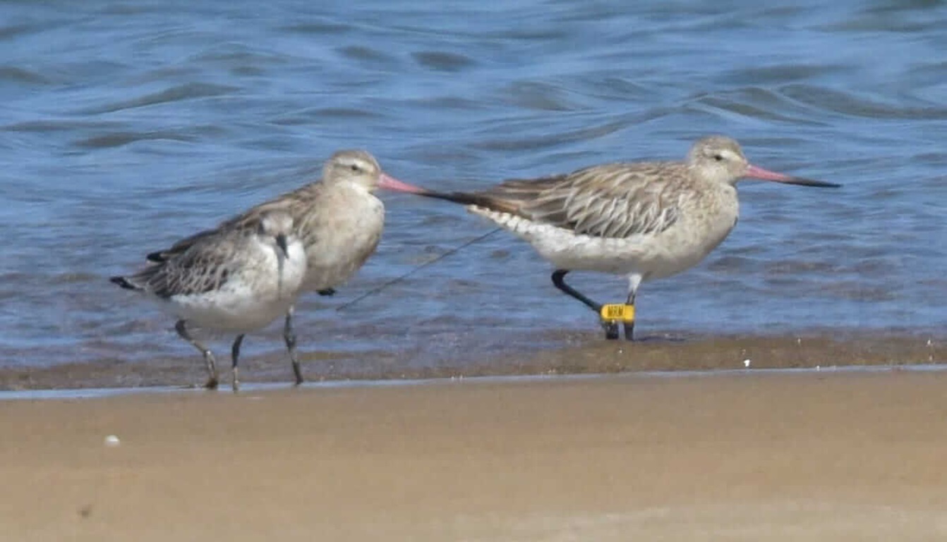
Top right and bottom left photos: Migratory shorebirds in the Exmouth Gulf showing Bar-tailed Godwit fitted with an engraved leg flag, yellow MRM. This godwit has been fitted with a small satellite transmitter; the black antenna can be seen by the bird’s tail feathers (as indicated by the red outline). It was tracked migrating from the Exmouth Gulf, northward through the Yellow Sea area to its breeding grounds on the Siberian Tundra, before returning to the Exmouth Gulf. Image credit Grant Griffin
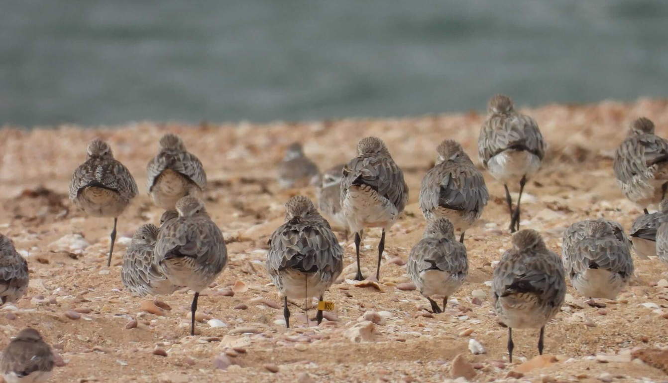
Bottom right photo: A flock of migratory shorebirds roosting in the Exmouth Gulf. A Bar-tailed Godwit fitted with an engraved leg flag, yellow MSC can be seen in the middle of the image. This godwit has been fitted with a small satellite transmitter; the black antenna can be seen under the bird’s tail feathers. It was tracked migrating from the Exmouth Gulf, northward through the Yellow Sea area to its breeding grounds on the Siberian Tundra, before returning to the Exmouth Gulf. Image credit Grant Griffin
Movement and behaviour of northbound migrating Pygmy Blue Whales from the Ningaloo Region
The offshore waters of Ningaloo are important foraging habitat for pygmy blue whales, a threatened and migratory species. Working with the Australian Institute of Marine Science (AIMS) and Centre for Whale Research (CWR), Woodside supported a satellite tagging program in May 2023 off Ningaloo. To locate pygmy blue whales over a large area off Ningaloo, vessel-based observations, aerial surveys (via spotter plane) and in-water listening stations were utilised. When sighted a small, fast-moving vessel was used to approach an individual pygmy blue whale and attach satellite tags. Unfortunately, weather conditions were unfavourable for whale tagging for the majority of the 11-days on site but one whale was successfully tagged with a GPS tag and dive logger. This whale swam more than 2000 km to just east of Timor-Leste in around six weeks with diving depths of up to 300 m. The importance of Ningaloo offshore waters for whales was confirmed with the researchers reporting over 100 pygmy blue whale sightings and acoustic detections of their vocalisations on the field trip, as well as active feeding by pygmy blue whales and even a number of sperm whale sightings.
Building on research supported over 2021-2023 on pygmy blue whales, the data collected highlights the northbound migratory pathways of individual whales are largely within the designated migratory biologically important area (BIA). Further, using the data from the dive loggers, migratory swimming, exploratory dives, foraging and actual feeding behaviours were identified. Foraging and feeding occurred at known feeding locations, as well as outside these areas. Pygmy blue whales were lunge feeding at depths >300 m depth in canyon habitat of the slope environments and off the continental shelf edge of Western Australia. At Ningaloo there is evidence of surface feeding behaviour. From the low number of tagged whales tracked through the North West Shelf area the whales are clearly migrating rapidly through the region, with much lower residency than at Perth Canyon (their main feeding area in WA). The research findings were finalised in 2024 and the peer-reviewed publication details the tracking of foraging and lunge feeding behaviour of nine pygmy blue whales along their northbound migratory paths for the first time – Tracking pygmy blue whale diving behaviour and validation of foraging areas defined from horizontal movement data - ScienceDirect
The innovation and knowledge outcomes of the study so far are summed up by Dr Thums, AIMS, the Principal Investigator and Senior Research Scientist: “Previously, our understanding of where foraging occurred was based on areas where the whales spent more time, gleaned from satellite tracking data. But foraging happens at depth so our approach of combining satellite tags with dive loggers allowed us to track their dives into the ocean depths along their migratory paths for the first time. Correctly delineating their foraging areas is important to effectivity manage potential threats to this species and to protect critical habitats.”
King Reef within Exmouth Gulf
King Reef became Australia’s first integrated artificial reef in 2018, repurposing steel structures donated from Woodside’s Griffin Field augmented with purpose built concrete reef modules. The reef was a result of a five-year community vision, which was expanded due to the formation of a consortium including the Western Australian State Government, academia, engineers, Woodside and Recfishwest. King Reef experienced rapid colonisation post deployment, exceeding the expectations of abundance, species diversity and biomass of fishes observed at natural reef and sand habitats in the Exmouth Gulf. Over 100 species of fish were observed through community monitoring in the first four years. The reef is now championed by the local recreational fishing community, supported by a Woodside funded reef monitoring and citizen science project and is a pioneer of successful marine habitat enhancement, utilising repurposed infrastructure from the oil and gas industry. In 2022, the ongoing King Reef research and monitoring program supported the local community and contributed over 100 hours of baited remote underwater video footage on the reef. This included what experts believe to be the first sighted juvenile red emperors on film in the Exmouth Gulf. The baited remote underwater video footage has also driven community engagement by highlighting the reef’s rapid ecological development.
In 2024, Woodside and Recfishwest continued to progress a focused science program to document and quantify the biodiversity value of attached marine life (sponges, soft corals etc) creating natural habitat on the introduced hard substrate.